
Forestry Pro II Laser Rangefinder
Description
Forestry Pro II Rangefinder
The Forestry Pro II is an evolved model of the current Forestry Pro which has been highly acclaimed as a simple surveying instrument for forestry. Inheriting functions useful for simple measurement that the existing model employs such as actual distance, horizontal distance, height, angle and vertical separation (difference in height between two targets) measurement functions, and three-point measurement (height between two points), the Forestry Pro II extends the maximum measurement range with improved accuracy of measured results, as evolved points. Also, the measurement response time until results are displayed has been shortened. This new model achieves measurement of longer distances than the original Forestry Pro while providing more accurate and faster response.
The external display has a higher pixel count making it easier to view than the previous model. Backlighting is newly employed so that the display can be viewed easily even in dark situations, such as for forestry. There are three levels of backlight brightness that can be adjusted according to the light conditions.
In addition, a log function is employed for storing up to 250 measurement results. This log can be referred to on the external display, for more convenient use.
Features:
- Measurement range: 7.5-1,600m/8-1,750 yd./25-5,250 ft.
- In addition to actual distance, horizontal distance, height, angle and vertical separation (difference in height between two targets) measurement functions, three-point measurement (height between two points) is available
- The results are displayed on both internal and external LCD panels. The external panel displays all results simultaneously.
- The external display employs backlighting for easy visibility even in dark situations, such as for forestry. Backlight brightness is adjustable to three levels.
- The log function enables up to 250 measurement results to be stored
- Quick and stable measurement response regardless of distance — HYPER READ
- The measurement result can be displayed in approx. 0.3 second on the internal display
- Target Priority Switch System for measuring overlapping subjects:
First Target Priority mode displays the distance of the closest subject — useful when measuring the distance to a subject in front of an overlapping background.
Distant Target Priority mode displays that of the farthest subject — useful in wooded areas. - High-quality 6x monocular with multilayer coating produces bright, clear images
- Long eye relief design affords eyeglass wearers easy viewing
- Dioptre adjustment function
- Single or continuous measurement (up to 8 seconds)
- Waterproof (up to 1m/3.3 ft for 10 minutes) and fogproof, but not designed for underwater usage; the battery chamber is rainproof
- Wide temperature tolerance: -10°C to +50°C/14°F to 122°F
Internal display | ||
| 7. Target Priority mode (1st: | 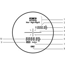 |
External display | ||
|
When measuring upward | |
Measurement example (Three-point measurement: height between two points) | ||
   | ||
| When three-point measurement is achieved, the height between points 2 and 3 is displayed on the internal LCD with Hor Hgt+Hgt2 (solid), and Hgt(2) and Ang(2) are shown on the external LCD. Points 2 and 3 can be reversed. | ||
Measurement example (two-point height measurement) | ||
   | ||
When the measurement is successful, you see the height from the base to the top displayed on the internal LCD with Hgt+Hgt2 (solid).
| ||


| Forestry Pro II | |
|---|---|
| Measurement range | Distance: 7.5-1,600m/8-1,750 yd./25-5,250 ft. Angle: ±89° |
| Maximum measurement distance (tree)* | 1,100m/1,200 yd./3,600 ft. |
| Distance display (increment) | [Internal Display] Act (Actual Distance): Main-indicator: every 0.1m/yd./ft. Sub-indicator: every 0.1m/yd./ft. (shorter than 999.9m/yd./ft.) every 1m/yd./ft. (1000.0 m/yd./ft. and over) Hor (Horizontal Distance) and Hgt (Height): every 0.1m/yd./ft. Ang (Angle): every 0.1° [External Display] Act (Actual Distance), Hor (Horizontal Distance) and Hgt (Height): every 0.1m/yd./ft. Ang (Angle): every 0.1° |
| Accuracy** (actual distance) | ±0.3 m/±0.3 yd./±0.9 ft (shorter than 1,000 m/1,000 yd./3,280 ft) ±1.0 m/±1.0 yd./±3.0 ft (1,000 m/1,000 yd./3,280 ft and over) |
| Magnification (x) | 6 |
| Effective objective diameter (mm) | 21 |
| Actual field of view (°) | 7.5 |
| Exit pupil (mm) | 3.5 |
| Eye relief (mm) | 18.0 |
| Dimensions (LxHxW) (mm/inch) | 110 x 74 x 42/4.3 x 2.9 x 1.7 |
| Weight (excluding battery) (g/oz.) | 170/6.0 |
| Power source | CR2 lithium battery x 1 (DC 3V) Auto power shut-off (after approx. 30 sec. unoperated) |
| Waterproof structure | Waterproof (up to 1m/3.3 ft. for 10 minutes), fogproof Battery chamber is rainproof — JIS/IEC protection class 4 (IPX4) equivalent (under Nikon's testing conditions) |
| Laser classification | IEC60825-1: Class 1M/Laser Product FDA/21 CFR Part 1040.10: Class I Laser Product |
| Electromagnetic compatibility | FCC Part15 SubPartB class B, EU:EMC directive, AS/NZS, VCCI classB, CU TR 020, ICES-003 |
| Environment | RoHS, WEEE |
- *Under Nikon's measurement conditions and reference values.
- **Under Nikon's measurement conditions.
The specifications of the product may not be achieved depending on the target object's shape, surface texture and nature, and/or weather conditions.